


Haines - Alaska
by Juergen Weiss


Title
Haines - Alaska
Artist
Juergen Weiss
Medium
Photograph
Description
SOLD on 04/05/2013 as a Archival Matte Paper / Framed to a Buyer from Pittsburgh
SOLD on 09/16/2015 as a Greeting Card / Single to a happy Buyer from Issaquah, WA
SOLD on 04/11/2016 as a Greeting Card / Single to a happy Buyer from Ketchikan, AK
SOLD on 11/19/2021 as a Puzzle - 20" x 28" (1,000 Pieces) to a Buyer from Beaverton
SOLD on 12/02/2021 as a Puzzle - 20" x 28" (1,000 Pieces) to a Buyer from Haines, AK
SOLD on 01/02/2022 as a Puzzle - 18" x 24" (500 Pieces) to a Buyer from Albany, OR
SOLD on 02/22/2022 as a Puzzle - 20" x 28" (1,000 Pieces) to a Buyer from Koloa, HI
SOLD on 09/07/2023 as a Luster Print (framed) to a Buyer from Lake Forest, CA
SOLD on 12/04/2023 as a Luster Photo Paper (framed) to a Buyer from Juneau, AK
SOLD on 03/14/2024 as a Luster Photo Paper to a happy Buyer from Kamuela, HI
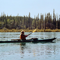
HAINES, as seen from the Chilkoot Inlet, is located in south-east Alaska, between breathtaking mountains. It is in the northern part of the Alaska Panhandle, near Glacier Bay National Park and Preserve.
The area around present-day Haines was called "'Dtehshuh" or "end of the trail" by the Chilkat group of Tlingit. It received this name because they could portage (carry) their canoes from the trail they used to trade with the interior, which began at the outlet of the Chilkat River, to Dtehshuh and save 32 km (20 mi) of rowing around the Chilkat Peninsula.
The first European, George Dickinson, an agent for the North West Trading Company, settled at Dtehshuh in 1880. In 1881, the Chilkat asked Sheldon Jackson to send missionaries to the area. Samuel Hall Young, a Presbyterian minister, was sent. He built the Willard mission and school at Dtehshuh, on land given the church by the Chilkat. The mission was renamed Haines in 1884 in honor of Francina E. Haines, the chairwoman of the committee that raised funds for its construction.
At the time the boundary between Canada and the U.S. was disputed and vaguely defined. There were overlapping land claims from the United States' purchase of Alaska from Russia in 1867 and British claims along the coast. Canada had requested a survey after British Columbia united with it in 1871, but the idea was rejected by the United States as being too costly given the area's remoteness, sparse settlement, and limited economic or strategic interest.
The Klondike Gold Rush of 1898/1899 changed the region greatly. The population of the area reached 30,000, composed largely of Americans. Haines grew as a supply center, since the Dalton Trail from Chilkat Inlet offered a route to the Yukon for prospectors. Gold was also discovered 36 miles (58 km) from Haines in 1899 at the Porcupine District. During this time the name Haines came into use for the area around the mission and not for just the mission itself.
The sudden importance of the region increased the urgency of fixing an exact boundary. There were reports that Canadian citizens were harassed by the U.S. as a deterrent to making any land claims. In 1898 the national governments agreed on a compromise, but the government of British Columbia rejected it. U.S. President McKinley proposed a permanent lease of a port near Haines, but Canada rejected that compromise.
The economy continued to grow and diversify. Four canneries were constructed around the mission by 1900. However, the completion of the White Pass and Yukon Route railway in neighboring Skagway that same year led to the Dalton Trail's eventual abandonment and Haines' economic decline.
In 1903, the Hay-Herbert Treaty entrusted the border decision to arbitration by a mixed tribunal of six members, three American and three Canadians British, who determined in favor of the United States, resulting in the present-day border.
Fort William H. Seward, a United States Army installation, was constructed south of Haines in 1904, on property donated by the mission from its holdings. In 1922, the fort was renamed Chilkoot Barracks. It was the only United States Army post in Alaska before World War II. During World War II, it was used as a supply point for some U. S. Army activities in Alaska. The fort was deactivated in 1946 and sold as surplus property to a group of investors (Ted Gregg, Carl Heinmiller, Marty Cordes, Clarence Mattson, and Steve Homer) who called it Port Chilkoot, thus forming the Port Chilkoot Company. Port Chilkoot was incorporated as a city in 1956. In 1970, Port Chilkoot merged with Haines into one municipality. Heinmiller was Port Chilkoot's mayor for the majority of its existence as a separate city. In 1972, the fort was designated a National Historic Landmark and the name, Fort William H. Seward, was restored. (Resoource Wikipedia).
Uploaded
November 12th, 2009
Embed
Share
Similar Images


Comments (38)

Juergen Weiss
Thank you to my buyer from Kamuela, HI for the purchase. I wish you have a great joy with this image in your home. Thank you and Best wishes, Juergen


Jennifer Jenson
Gorgeous view, so beautifully captured. Congratulations on your many sales of this image!

Juergen Weiss
Thank you to my buyer from Juneau, AK. Haines reminds me always so beautiful memories and I wish this Image brings you a lot of joy ! Thank you and All the Best, Juergen


Will Borden
Hi Juergen~~This image of Haines, Alaska is magnificent- postcard perfect!! F&L!!
Juergen Weiss replied:
Thank you for commenting on one of my personal favourites, Will ! Such a beautiful place ♥ ♥ ...


Juergen Weiss
Thank you to my buyer from Pittsburgh, PA for the purchase. This image is one of my Favourits ... it reminds me so many great memories. I wish you have a great joy with this picture in your home. Thank you and All the Best, Juergen


Recently Viewed
